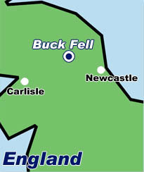
buck fell
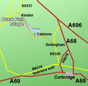
Buck Fell rally stage is located to the South of Kielder Village.
On a map look for - Corbridge, Northumberland
Leave Newcastle-upon-Tyne on the A69 West to Corbridge. Take the A68 North to Hadrians Wall and turn West on the B6318 to
Chesters Fort. Turn North on the B6320 to Bellingham. Turn West onto unclassified road to Stannersburn or Falstone. Follow the
road around the West side of the Water towards Kielder village. You should see arrows directing you to the stage to the West of the
road between the Northern point of Kielder Water and the village.
Location and routes are a guide only. Check before travelling.
When approaching the general area of the rally always look for and follow the
GREEN or ORANGE ARROWS.
They will guide you to stage parking or access points.
Spectators
Always follow the arrows and any directions given by marshals. They are trying to save you time and keep you safe. Motor sport is fun but dangerous.
Drivers/Co-Drivers/Teams
Always use the OS reference and/or maps supplied by the event organisers to ensure the correct event/stage start access point. If you require fuel,
in particular Shell visit the Shell
filling station locator website for the nearest supplier.
IMPORTANT NOTE
The Its My Stage Motorsport guide provides information on some stages used for rallying within the UK. It is impossible to show every rally stage as they are subject to regular change. Spectator access points are also subject to change. Please ensure you contact the rally organisers for details before travelling. Any maps are sketches and not to scale. They offer a representation and you should use them as a guide only. For detailed information on locations please contact organisers or use a facility such as google maps, multimap, or ordnance survey.
 |