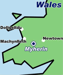
myherin
Myherin rally stage is at a high altitude within the Cambrian Mountains to the East of the coastal town of Aberystwyth.
On a map look for - Newtown, Powys
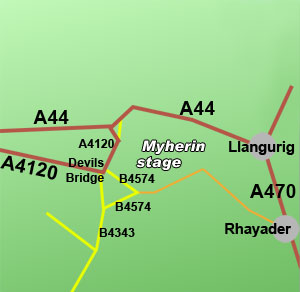
From Newtown, Powys take the A489 West then the A470 South To Llangurig. Take the A44 West to Ponterwyd then South on the
A4120 to Devils Bridge. Take the B4574 SE. Arrows should direct you to the stage.
Location and routes are a guide only. Check before travelling.
When approaching the general area of the rally always look for and follow the
GREEN or ORANGE ARROWS.
They will guide you to stage parking or access points.
Spectators
Always follow the arrows and any directions given by marshals. They are trying to save you time and keep you safe. Motor sport is fun but dangerous.
Drivers/Co-Drivers/Teams
Always use the OS reference and/or maps supplied by the event organisers to ensure the correct event/stage start access point. If you require fuel,
in particular Shell visit the Shell
filling station locator website for the nearest supplier.
IMPORTANT NOTE
The Its My Stage Motorsport guide provides information on some stages used for rallying within the UK. It is impossible to show every rally stage as they are subject to regular change. Spectator access points are also subject to change. Please ensure you contact the rally organisers for details before travelling. Any maps are sketches and not to scale. They offer a representation and you should use them as a guide only. For detailed information on locations please contact organisers or use a facility such as google maps, multimap, or ordnance survey.
 |