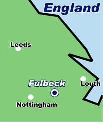
fulbeck
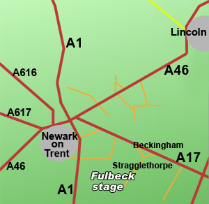
Fulbeck rally stage is on old RAF Fulbeck Airfield used by the RAF and later the USAAF during WWII. It is now used by
various commercial enterprises including a kart racing track. Access is from Stragglethorpe Lane through the village
of Stragglethorpe South of the A17. Ignore any signs for Fulbeck village.
Closest Motorway -
Closest A road - A17
Closest B road -
Post Code - NG32 2AY
Map reference -
Co-ordinates - 53°02.57N 00°39.32W
Google maps link - press here
When approaching the general area of the rally always look for and follow the
GREEN or ORANGE ARROWS.
They will guide you to stage parking or access points.
Spectators
Always follow the arrows and any directions given by marshals. They are trying to save you time and keep you safe. Motor sport is fun but dangerous.
Drivers/Co-Drivers/Teams
Always use the OS reference and/or maps supplied by the event organisers to ensure the correct event/stage start access point. If you require fuel,
in particular Shell visit the Shell
filling station locator website for the nearest supplier.
IMPORTANT NOTE
The Its My Stage Motorsport guide provides information on some stages used for rallying within the UK. It is impossible to show every rally stage as they are subject to regular change. Spectator access points are also subject to change. Please ensure you contact the rally organisers for details before travelling. Any maps are sketches and not to scale. They offer a representation and you should use them as a guide only. For detailed information on locations please contact organisers or use a facility such as google maps, multimap, or ordnance survey.
 |